

Hyperspectral Imaging
Hyperspectral imagery consists of hundreds of "spectra," or measurements of reflected or emitted energy. Hyperspectral sensors sensors scan many channels across a relatively narrow bandwidth and provide detailed information about target spatial and spectral patterns. Absorption and emission bands of given substances often occur within very narrow bandwidths. They allow high-resolution, hyperspectral sensors to distinguish the properties of the substances to a finer degree than an ordinary broadband sensor. The intensity of this energy can be measured at various wavelengths. Many objects and substances have spectral characteristics that are unique and a unique spectral "signature" allows that object or substance to be identified through various spectral analyses. By using sensors to detect multiple wavelengths, it's possible to differentiate between natural and manmade objects - even different kinds of vegetation and various types of building materials.
The utility of subdividing the ultraviolet, visible and infrared spectra into distinct bins for imaging has long been known. In Multispectral Imaging (MSI), multiple images of a scene or object are created using light from different parts of the spectrum. If the proper wavelengths are selected, multispectral images can be used to detect many militarily important items such as camouflage, thermal emissions and hazardous wastes to name a few.
A primary goal of using multispectral/hyperspectral remote sensing image data is to discriminate, classify, identify as well as quantify materials present in the image. Another important applications are subpixel target detection, which allows one to detect targets of interest with sizes smaller than the pixel resolution, and abundance estimation, which allows one to detect concentrations of different signature spectra present in pixels. In remote sensing image analysis, the difficulty arises in the fact that a scene pixel is mixed linearly or nonlinearly by different materials resident in the pixel where direct applications of commonly used image analysis techniques generally do not work well.


Hyperspectral Imaging (HSI), like MSI, is a passive technique (i.e., depends upon the sun or some other independent illumination source)m but unlike MSI, HSI creates a larger number of images from contiguous, rather than disjoint, regions of the spectrum, typically, with much finer resolution. This increases sampling of the spectrum provides a great increase in information. Many remote sensing tasks which are impractical or impossible with an MSI system can be accomplished with HSI. For example, detection of chemical or biological weapons, bomb damage assessment of underground structures, and foliage penetration to detect troops and vehicles are just a few potential HSI missions.
Hyperspectral imaging technology uses hundreds of very narrow wavelength bands to "see" reflected energy from objects on the ground. This energy appears in the form of "spectral fingerprints" across the light spectrum and enables collection of much more detailed data and produce a much higher spectral resolution of a scene than possible using other remote sensing technologies.
Once these fingerprints are detected, special algorithms-repetitive, problem-solving mathematical calculations-then assess them to differentiate various natural and manmade substances from one another. "Signature" libraries may also be used to identify specific materials-e.g., rooftops, parking lots, grass, or mud-by comparing a library's pre-existing reference catalogs with freshly taken hyperspectral images of the battlefield from space.
Image processing equipment then portrays the various types of terrain and objects upon it in different colors forming a "color cube," each based on the wavelength of the reflected energy captured by the image. These colors are subsequently "translated" into maps that correspond to certain types of material or objects to detect or identify military targets such as a tank or a mobile missile launcher. Algorithms can also categorize types of terrain and vegetation (useful, for example, in counter-narcotic operations), detecting features such as disturbed soil, stressed vegetation, and whether the ground will support the movement of military vehicles.
Once this technology is mature, theater commanders can use mobile ground stations to process in real-time information transmitted by the satellite, critical to theater commanders for them to keep pace with rapidly changing conditions.
Hyperspectral Imaging: a 21st Century Tool for Resource Management
Hyperspectral Imaging: a 21st Century Tool for Resource Management. A New Way to Look at the World.
Hyperspectral Remote Sensing
The application of hyperspectral imaging to the terrestrial environment began with airborne mineral mapping in the late 1970s and early 1980s. A major advance occurred in 1989 when the NASA/JPL AVIRIS system became operational.
HYPERSPECTRAL SENSORS
HYPERSPECTRAL SENSORS. John Kerekes Lincoln Laboratory Massachusetts Institute of Technology Lexington, Massachusetts. Introduction.
Hyperspectral imaging
This article has been copied from SPIE. Due to performance problems it is being stored locally. From OE Reports, November 1994 issue.
TRW Press Release
For further info, contact TRW Media Relations Fax: 310.814.4507. TRW Completes Fabrication of Hyperspectral Imager for NASA's Small Spacecraft Technology.
NASA/SSTI - TRW/Lewis
SSTI Homepage || CRSP Homepage || Commercial Partners || Educational Partners || Comments || Help Register to use the MDMS Archive || Query the MDMS...
ESDX Presentation by Doug Sigler (TRW)
ESDX-ECIT'95 Presentation by Doug Sigler (TRW) Next-Generation Environmental, Health and Safety Information Systems. Session S17-ENT: Thursday 12 October..
TRW Press Release
TRW, RF MICRO DEVICES TEAM TO PRODUCE ADVANCED SEMICONDUCTOR CHIPS. CLEVELAND, March 14, 1996 -- TRW Inc. and RF Micro Devices (RFMD)
The AVIRIS (Airborne Visible/Infrared Imaging Spectrometer) is a proven instrument in the realm of Earth Remote Sensing. It is a unique optical sensor that delivers calibrated images of the upwelling spectral radiance in 224 contiguous spectral channels (bands) with wavelengths from 400 to 2500 nanometers. AVIRIS has been flown on two aircraft platforms: a NASA ER-2 jet and the Twin Otter turboprop. The ER-2 is a U2 aircraft modified for increased performance which flies at approximately 20 km above sea level, at about 730 km/hr. The Twin Otter aircraft flies at 4km above ground level at 130km/hr. AVIRIS has flown North America, Europe, portions of South America, and most recently, Argentina. The main objective of the AVIRIS project is to identify, measure, and monitor constituents of the Earth's surface and atmosphere based on molecular absorption and particle scattering signatures. Research with AVIRIS data is predominantly focused on understanding processes related to the global environment and climate change.
In 1997 researchers at the Naval Research Laboratory (NRL) successfully demonstrated autonomous, real-time, hyperspectral detection of airborne targets and military ground targets. This was achieved with realtime autonomous cueing of a high resolution imager and designation of targets with pointing optics and a pulsed laser. The work, performed under NRL's "Dark Horse" Program, demonstrated the potential capabilities needed for autonomous Uninhabited Combat Air Vehicles (UCAV). The flight tests were conducted aboard a P-3 aircraft provided by NRL's Flight Detachment Group, Patuxent River Naval Air Station, Maryland. Land targets were located at the U.S. Army's Fort A. P. Hill in Virginia. Hyperspectral detection algorithms developed by NRL under the Joint Multi-Spectral Program (JMSP) were implemented on a realtime processor built by Space Computer Corporation in Los Angeles. Two algorithms, operating simultaneously in an "AND" mode to reduce false alarms, produced a cueing signal upon target detection. Cued high resolution imagery was obtained using NRL's Recon Optical Inc (ROI) CA 260 25-megapixel camera and data were transmitted to a ground station at NRL in Washington, DC, using Advanced Tactical Airborne Reconnaissance System (ATARS) Common Data Link (CDL). In addition to ground targets, the capability to autonomously detect and to cue on moving targets in realtime was demonstrated for a target aircraft flying 4,000 feet below the P-3. The NRL "Dark HORSE" Program funded by NRL/Office of Naval Research (ONR) is a four year effort to develop and demonstrate realtime hyperspectral detection, cueing, target location, and target designation capabilities.
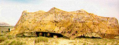
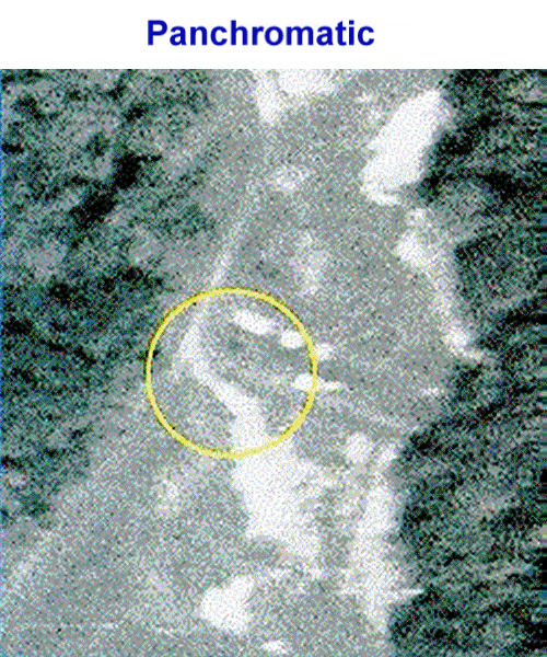
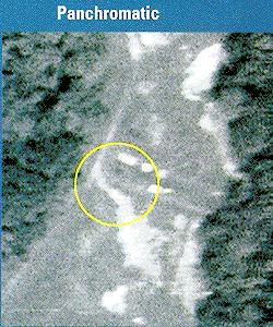
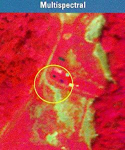
DARPA's Adaptive Spectral Reconnaissance Program (ASRP) is performing research and developing technology to provide the capability to defeat Camouflage, Concealment, and Deception (CC&D) and other difficult targets through the use of hyperspectral technology. DARPA's emphasis is on the technical underpinnings for future MSI/HSI systems to counter camouflaged, and concealed surface targets. Our approach is based on quantitative modeling methods validated through data collects conducted jointly with other members of the hyperspectral community. ASRP will leave behind models, tools and algorithms, a database of targets and backgrounds, and the demonstrated sensor and system capability. DARPA is focusing attention on technology challenge areas (e.g., false alarm rate reduction and compact LWIR sensor) to establish the feasibility of integrating this technology into airborne reconnaissance operations.
The Hyperspectral Digital Imagery Collection Experiment (HYDICE) is an airborne hyperspectral imaging sensor with 210, 10nm spectral bands in the 400-2500nm range. The purpose of collecting insitu optical data that is coincident with the HYDICE data is to develop and improve algorithms that convert remote sensing reflectance (Rrs) signatures to the inherent optical properties (IOPs)
The interpretation of hyperspectral signatures of land targets has largely been approached as an ad hoc search for robust features in large amounts of empirical data. Results have been very promising, but so far a real scientific understanding of the phenomena and a predictive capability for the signatures under complex environmental and terrain conditions are immature. Good predictive models of either the targets or the clutter in the real world environment are lacking. The interpretation of the resulting images has been much more successful by human photo interpreters than by real-time ATR.
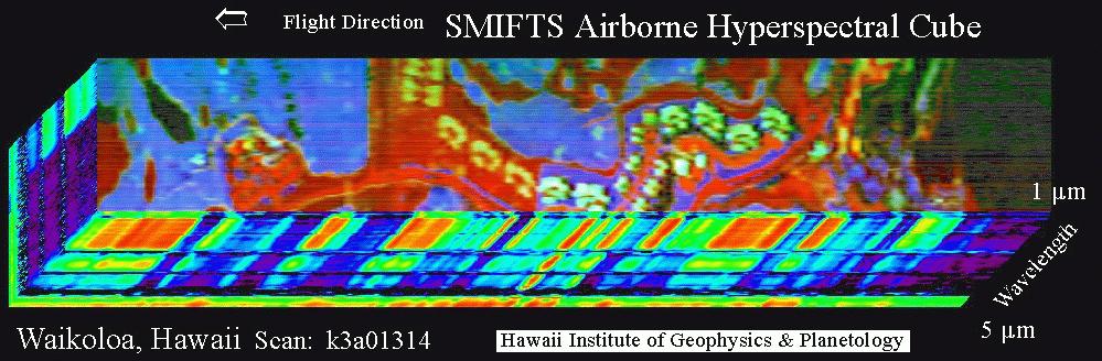
This image of Waikoloa, HI was obtaind at a flight altitude of 6000 feet. The top face of the image cube is a three channel color composite with: red= 3.73 um; green = 2.12 um; blue = 1.27 um. The base of the image cube is at approximately 5 um. Sides of the cube show, in pseudocolor, the intensity of spectral response of the pixels along the edge of the image, with red being the greatest and dark blue/black the least. Vegetated areas are bright in the shorter wavelengths; rocky areas are bright in the longer wavelengths.
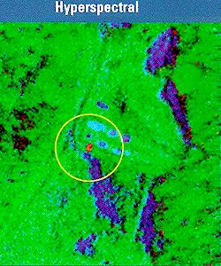
Features in image: Ocean to right. Most other black areas are water hazards on golf course or trees. Grassy areas are blue; light blue are sand traps. Red are asphalt, bare rock or gravel. Bright white/green areas are condominium roofs. Yellow/green structures (in large red area) are concrete foundations for new condominiums.
|
NEWSLETTER
|
| Join the GlobalSecurity.org mailing list |
|
|
|